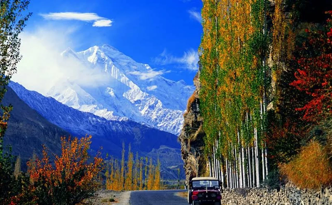
Few places in Pakistan earn the word "breathtaking" as honestly as Hunza. The valley sits in the far north of Gilgit-Baltistan, cut deep into the Karakoram range, with the Hunza River running silver-grey through the bottom and walls of rock and ice climbing seven thousand metres above it. Rakaposhi, at 7,788 metres, dominates the southern skyline; Ultar Sar, at 7,388 metres, stands guard over the town of Karimabad. On a clear morning the whole scene looks less like a destination and more like a painting somebody forgot to finish.
But Hunza is not only about mountains. It is also one of the most welcoming, best-educated and most peaceful regions in the country, home to the Burusho people, who speak Burushaski, a language with no proven relatives anywhere in the world. Add centuries of fortress-building, orchards that erupt into blossom every spring, and one of the great mountain roads on earth, and you have a place that rewards a week of unhurried travel far better than a rushed weekend.
Karimabad and the two forts
Most travelers base themselves in Karimabad, the valley's main town, which climbs a hillside above the river. Above it stands Baltit Fort, the old seat of the Mirs of Hunza, whose oldest parts are commonly dated to several centuries ago. The fort was carefully restored by the Aga Khan Trust for Culture and now operates as a museum, with low wooden doorways, a royal throne room and a rooftop that gives you the best view in town. Give it a couple of hours, and take the guided tour if you can; the stories about how the ruling family lived, ruled and defended the valley bring the rooms to life.
A short walk away, Altit Fort is older and more austere. Its mud-and-timber rooms cluster on the edge of a cliff above terraced fields, and the surrounding village of Altit is a wonderful place to wander among stone lanes and apricot trees. If Baltit is the polished showpiece, Altit is the one that feels lived in by history.
Eagle's Nest and the great viewpoints
For sunrise and sunset, head up to the Eagle's Nest viewpoint near Duikar. From the terrace you can see Rakaposhi, Ultar Sar, Golden Peak and Lady Finger stacked along the horizon, with the valley falling away below. Go early: the light turns the snow pink and then gold in the space of twenty minutes, and the crowds are still at breakfast. Another good option is the walk up to the Ultar Meadows, a full day's effort that pays off with a close look at the glacier-fed streams and the base of Ultar Sar.
Attabad Lake, Passu and Gulmit
North of Karimabad the Karakoram Highway climbs toward the border, and the scenery gets bigger with every bend. Attabad Lake did not exist before January 2010, when a massive landslide dammed the Hunza River and flooded the valley behind it. Today its turquoise water is one of Gilgit-Baltistan's most photographed sights, and boat rides across it are a popular stop. The road that once ran through the drowned section now passes through a series of tunnels built beside the lake.
Farther on you reach Gulmit, with its small museum and traditional houses, and then Passu, where the jagged Passu Cones rise like cathedral spires above the road. The nearby Hussaini suspension bridge is a rite of passage for adventurous visitors: a long, sagging walkway of gaps and planks strung across the river. Cross it slowly, or simply photograph it from the bank; either way it makes a memorable afternoon. Borith Lake, near Gulmit, is a quieter spot for birdwatching and a picnic.
Up to Khunjerab Pass
The highest point on the Karakoram Highway is Khunjerab Pass, at roughly 4,700 metres, where Pakistan meets China. The road up passes through Khunjerab National Park, where with luck and patience you may spot ibex, marmots and even the elusive snow leopard's tracks. The air is thin, so go slowly, drink water and do not be alarmed if the walk from the car to the border marker leaves you breathless. The pass is generally open for visitors in the warmer months, and access can change with weather and border arrangements, so check current conditions before you plan a day around it.
When to go
Hunza has two seasons that photographers dream about. In April, the apricot, cherry and almond orchards bloom in white and pink against a backdrop of snow, and the days are cool and clear. In October, the poplars and apple trees turn gold and the crowds thin out; we have written more about this in our post on autumn in Hunza. Summer, from June to August, is warm and green and the best time for high-altitude trekking, though the main road can be busy with domestic tourists. Winter is cold and quiet, and some guesthouses close.
Getting there
The classic route is the Karakoram Highway from Islamabad through Abbottabad, Besham and Chilas to Gilgit, then on to Karimabad, which is a long but spectacular two-day journey. Many travelers break it at Besham or Chilas. Flights from Islamabad to Gilgit exist but are weather dependent, and a cancelled flight can wreck a tight schedule, so build in slack if you fly. Once you are in the valley, private vehicles with local drivers are the easiest way to move between viewpoints, and the roads are generally good, apart from occasional landslide clearances.
Food and where to stay
Hunza's food is simple and delicious. Try chapshuro, a savoury meat-filled pastry, diram phitti, a sweet wheat bread, and anything made from apricots: dried fruit, jam, apricot oil and the kernels that locals crack open at every meal. Guesthouses in Karimabad range from budget rooms with a shared bathroom to comfortable hotels with valley-facing balconies. Book ahead in April and October, when rooms with a view sell out first.
Practical tips
Bring layers, since mornings and evenings are cold even in summer, and pack a good pair of walking shoes for the uneven stone streets. Carry cash, as ATMs can be unreliable, and download offline maps before you leave the main towns. Dress modestly out of respect for local custom, and always ask before photographing people. Hunza is known for its hospitality, and a little courtesy goes a long way.
If you want a trip built around the very best of the valley, our tour packages include experienced local guides, permits and comfortable stays. Have a question about dates or routes? Get in touch and we will help you plan it.